The Express
In 1808 a twenty-year-old surveyor from Albany began measuring Manhattan for streets nobody had approved yet.
The people who owned the land sued him. The sheriff arrested him. A former mayor kept posting his bail.
Ten years later, one landowner called the whole business tyranny. Then the streets reached his estate, and everything changed.

In 1808 a young man named John Randel Jr. walked to work most mornings past Thomas Paine’s house.
Randel boarded in the city, which then ended a little south of a salt meadow where Canal Street now runs. His office was more than a mile beyond it, at the corner of Christopher and Herring Streets in Greenwich (now known as Greenwich Village). He crossed the meadow’s ditch on a plank and followed a beaten path through half-fenced lots, with Aaron Burr’s old country seat a hundred yards or so to the west.
Herring Street is Bleecker Street now, and on it stood a two-story frame house where the author of Common Sense was living out his last year. Randel passed it almost daily, he wrote, and “frequently, in fair weather, saw him sitting at the south window.”1
Randel was twenty.7 He had come down from Albany that June as “Secretary and Surveyor” to a state commission with an unusual assignment: decide where the city’s future streets would go.1, 2 Before anyone could decide that, somebody had to measure the island. That was Randel’s job, and it meant walking onto other people’s land.
They didn’t take it well.
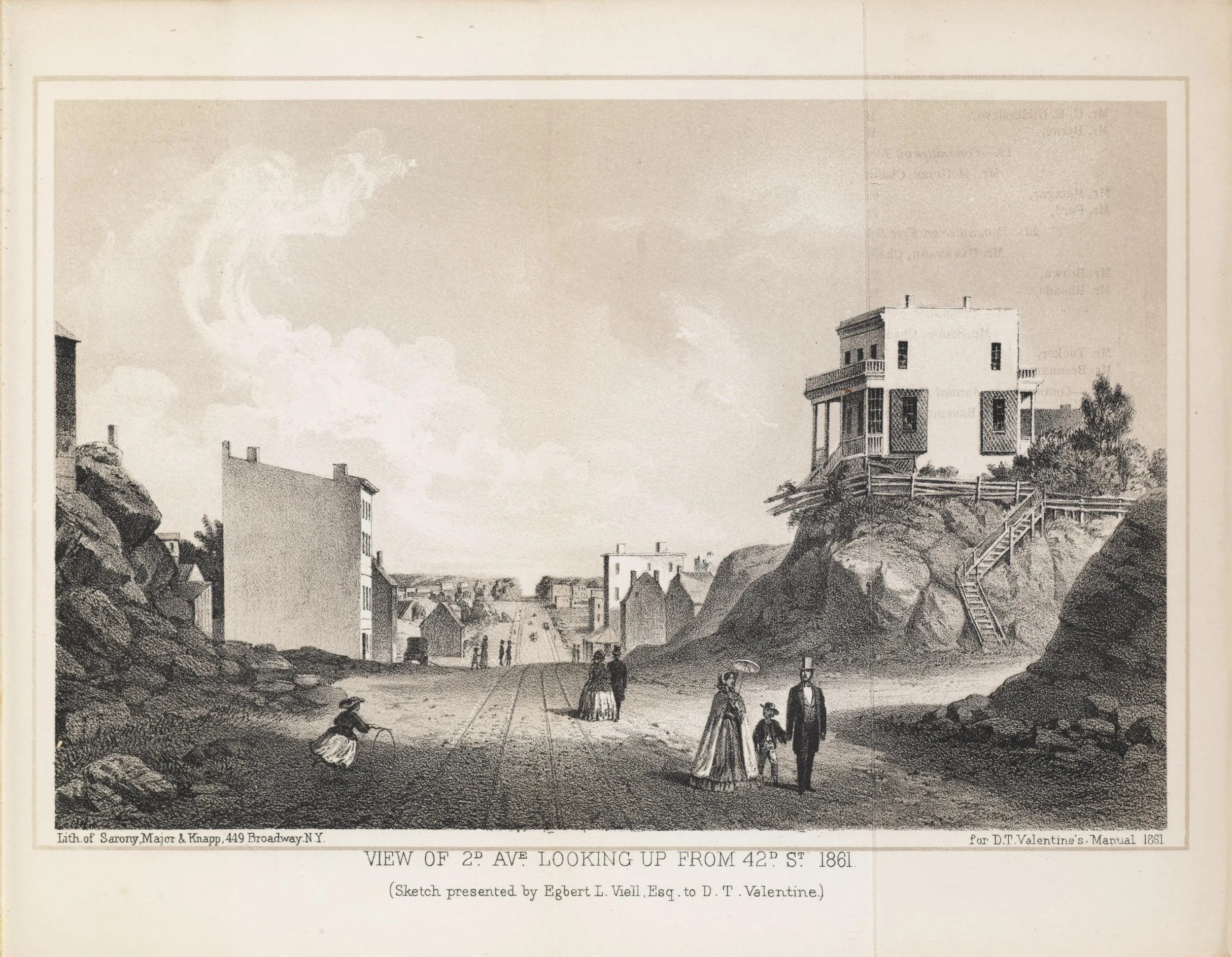
Original terrain of Manhattan and its hills. A house stranded above a new street.
Why the city wanted a plan
For nearly two centuries New York had let its streets happen. A landowner who wanted to sell lots laid out streets across his own property, pointed however suited him, and the city approved them afterward. The Dutch town at the tip of the island had followed a shoreline, a canal and a wall. Farther up, families like the De Lanceys and the Bayards drew neat grids of their own that met their neighbors’ at odd angles.3, 7
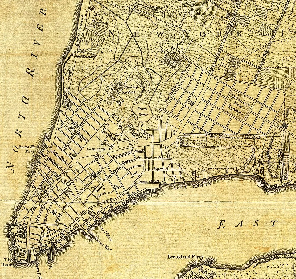
1776 Map - the DeLancey’s parceling their farm into grids to accommodate sales
That served well for a small port city. But between 1790 and 1810 the population tripled, to nearly 100,000, and the city was pushing north.3 In February 1807 the Common Council wrote to the legislature in Albany and listed its troubles. The evils, it said, were “continually accumulating by reason of our increasing population.” New streets ought “to unite regularity and order with the public convenience and benefit.” And the need to “promote the health of the City” was, the council said, obvious.4
Health was no small item. Yellow fever had struck in 1795, 1798, 1803 and 1805. The 1798 epidemic killed about 2,000 people, and those who could afford to leave fled north to Greenwich. Many doctors blamed bad air, the kind that collected in narrow lanes and closed courts.5
The city also had land to sell: about 1,300 acres in the middle of the island, surveyed into lots since 1785 and slow to find buyers.2
Then came the admission. The council could not do the job itself. There was “a radical defect” in its power, because whatever one council decided “may be disregarded or annulled by its successors.” And every plan brought “the incessant remonstrances of proprietors.”4
So, the city asked the state to take the decision out of its hands. On April 3, 1807, the legislature named three commissioners, gave them four years and “exclusive power” to lay out the streets, and declared that their map would be “final and conclusive.” Their surveyors could enter any property “in the day time.” The commissioners themselves were barred from buying land in the district while they served.6
The three were Gouverneur Morris, who had written the final draft of the United States Constitution, preamble included; Simeon De Witt, the state’s surveyor general; and John Rutherfurd, a former senator from New Jersey.3 They met seldom. Morris and Rutherfurd turned down the four dollars a day. De Witt, in Albany, had trained Randel as his apprentice, and when the commission’s first surveyor didn’t work out, he sent him south.2, 7
The sheriff and the former mayor
Randel’s crews carried chains and axes. To sight a straight line, they cut branches. To cross a farm, they walked through it. The owners understood what a survey was for. Some turned the men away. Some pulled up the markers once the men had gone.3
And some went to court. In August 1808, two months into the job, one owner sued for $5,000 in damages and was awarded $109.63.7 More suits followed, and with the commissioners absent, the sheriff came for the man on the ground. “I was arrested by the Sheriff, on numerous suits instituted against me as agent of the Commissioners,” Randel wrote, “for trespass and damage committed by my workmen, in passing over grounds, cutting off branches of trees, etc.”1
He did not stay arrested long. Richard Varick, who had been mayor for twelve years and whose country house stood a few hundred yards off Randel’s path to the office, “always provided bail for my appearance at Court.”1
The lawsuits nearly stopped the work. Because of them, Randel wrote, the commissioners told the city they could not finish. On March 24, 1809, the NYS legislature passed a second law. The surveyors could enter private ground and cut what they had to, and the city would pay for the damage afterward.1, 3
All this time there was no plan. For three seasons Randel mapped the island as it was: hills, streams, fences, barns. The commissioners left almost no record of their thinking. The historian Gerard Koeppel, who has studied what survives, concludes that they did not settle on a design until December 1810, four months before their deadline.2
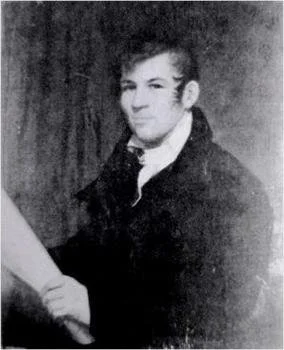
John Randel
Rectangles
What they chose was the plainest thing available. Twelve avenues a hundred feet wide would run north. One hundred fifty-five streets, most of them sixty feet wide, would cross the island about two hundred feet apart. There would be no circles, ovals or stars, the commissioners explained, because “a city is to be composed principally of the habitations of men,” and “strait-sided and right-angled houses are the most cheap to build and the most convenient to live in.”8
They left few open spaces. The rivers, “those large arms of the sea which embrace Manhattan Island,” would supply the fresh air.8 Union Place, today’s Union Square, was one of the few, and Randel gave the reason: the roads met there at an angle that “left so small an amount of ground for building purposes.”1
They expected to be laughed at for providing “space for a population greater than any spot on this side of China,” and guessed that in half a century the city might hold 400,000 people. To any owner who felt wronged they offered this: he should ask himself “whether his sensations would not have been still more unpleasant had his favorite plans been sacrificed to preserve those of a more fortunate neighbor.”8
De Witt signed in Albany on March 22, 1811, with Randel as a witness.1 Morris signed at the end of the month and the maps were filed with two days to spare.1
Randel, who drew them, was candid about what they amounted to. The commissioners had complied “with the letter, although not fully with the spirit” of the law. Of the 155 streets on the map, only 16 had even one marker in the ground to show where they would run. The rest existed only on paper.1
The commissioners went home. Randel stayed ten more years.
1,647 corners
The city hired him to put the map physically on the ground. At each future intersection his men set a white marble post, three feet long and nine inches square, cut with the numbers of the street and the avenue.3 Where the ground was rock they set an iron bolt instead. Randel counted them when he was done: 1,549 stones and 98 bolts.1
The land owners had not come around. They pulled up his wooden pegs before the stones could go in, and he had to measure the ground again.3 He also drew the island as it stood, on 92 large sheets: every house, barn, fence and lane, with the future streets ruled straight across them.2 A geographer who later counted the buildings on those sheets found 1,825 standing north of Houston Street. Of those, 721, about 39 percent, sat in the path of a street.3, 7
The best-remembered objection came in 1818, in a pamphlet published without its author’s name. He was Clement Clarke Moore, a scholar known today for “A Visit from St. Nicholas,” and he owned Chelsea, a family estate on the Hudson. His anger was aimed at the city government, which was opening the streets, leveling the hills and sending the owners the bill.
He wrote that “nothing is to be left unmolested which does not coincide with the street-commissioner’s plummet and level. These are men, as has been well observed, who would have cut down the seven hills of Rome.”
The street commissioner could “stretch out his hand, like Moses over the Red Sea; and command all within the reach of his eye to be overwhelmed.” It was “a tyranny of the worst kind.” And what did an owner get for the land taken from him? In most cases nothing, Moore wrote, except “the hope of a future rise in the value of their property.”9
“Made rich thereby”
The hope turned out to be ironically prophetic. Through the 1820s the city opened streets and avenues across Chelsea, and Moore began selling it by the lot, with rules about what buyers could build. In 1820 he had valued the estate at $17,000. In 1855 the Sun estimated his wealth at $600,000.3
Randel did not share in it. He left for canal work, was fired, sued, and in 1834 won a judgment of more than $226,000. He still died insolvent, in Albany, in August 1865.7
The year before, at seventy-six, he wrote down what he remembered of the survey for the city’s annual manual. He remembered the plank over the ditch and Paine at the window. He remembered who had posted his bail.
And he remembered the people who had sued him: “a few of the numerous opponents” of the work, “many of whose descendants have been made rich thereby.” The plan itself, he added, “is now the pride and boast of the city.”1
By then the grid had outrun its authors. The commissioners had guessed 400,000 people in fifty years. In 1860 there were twice that.3
It had also been overruled, twice. The first time was Broadway. The plan kept the old road only as far as 23rd Street. North of there, where it was called the Bloomingdale Road, it was to disappear under the blocks. People went on using it. Beginning in 1838 the city put it back on the map a stretch at a time, and the diagonal that was supposed to vanish now crosses the avenues at Madison, Herald and Times Squares and at Columbus Circle. The commissioners had ruled out circles.3
The second time was the park. The arms of the sea had not been enough. In 1853 the state set aside the middle of the island, and the streets Randel had staked across it were never built.7
One of his markers is still there. In 2004 a geographer and a surveyor searching Central Park found an iron bolt set in a rock, at the spot where, by the best reckoning, Sixth Avenue was to have crossed 65th Street. It is the only one generally accepted as Randel’s that remains where his men put it.10
He set it to mark a corner. The corner never came but 100’s of others have affected our lives ever since.

References
The small numbers in the story point to the sources below. They are there for review and come out before publication. Each entry ends with a note on how far the source can be trusted as it stands.
1. John Randel Jr., letter to David T. Valentine, April 6, 1864, and “City of New York, north of Canal street, in 1808 to 1821,” in D. T. Valentine, Manual of the Corporation of the City of New York for 1864, pp. 838–840 and 847–856. Internet Archive. Primary. Written 55 years after the events. Read as scanned text; quotations to be checked against the page images.
2. Gerard Koeppel with Jason M. Barr, “Myth #1: ‘Randel’s Matrix’” and “Myth #2: The Commissioners as Visionaries,” Gotham Center for New York City History, 2017. Myth #1; Myth #2. Secondary. Koeppel is the author of City on a Grid (2015).
3. Museum of the City of New York, The Greatest Grid: The Master Plan of Manhattan, 1811–Now (online exhibition, 2015). Pages used: “Before the Grid,” “Making the Plan,” “Broadway and Its Bowties,” “The Appointment of the Commissioners, 1807,” “Remarks of the Commissioners, 1811,” “The Commissioners,” “Surveying the City,” “The Marble Monument,” and “Moore’s Estate: Subdivision Plan.” Exhibition site. Secondary. Source for the 39 percent figure and Moore’s $17,000 and $600,000, none of which has been seen in the original.
4. Minutes of the Common Council of the City of New York, 1784–1831, vol. 4 (New York, 1917), pp. 353–354, meeting of February 16, 1807. Internet Archive. Primary. Read as scanned text.
5. Untapped New York, article on New York’s yellow fever epidemics, 1795–1805. Untapped New York. Lead only. The years and the 1798 toll are not yet verified.
6. Laws of New York, 1807, chapter 115, “An Act relative to Improvements, touching the laying out of Streets and Roads in the City of New-York, and for other purposes,” passed April 3, 1807. Museum transcription. Primary, in the museum’s transcription.
7. Wikipedia, “Commissioners’ Plan of 1811” and “John Randel Jr.,” citing Gerard Koeppel, City on a Grid: How New York Became New York (2015), and Marguerite Holloway, The Measure of Manhattan (2013). Commissioners’ Plan of 1811; John Randel Jr. Leads only. Not yet verified against the two books. Covers Randel’s age, the August 1808 suit, the private grids, the Central Park date, and Randel’s canal judgment and death.
8. “Remarks of the Commissioners for Laying Out Streets and Roads in the City of New York,” March 22, 1811. Museum transcription. Primary, in the museum’s transcription.
9. [Clement Clarke Moore], A Plain Statement, Addressed to the Proprietors of Real Estate, in the City and County of New-York (New York: J. Eastburn and Co., 1818), pp. 14, 39, 49 and 50. Internet Archive. Primary. Read as scanned text; quotations to be checked against the page images.
10. Atlas Obscura, “The Hidden Bolts That Drive Manhattan’s Infrastructure Nerds Nuts,” and Untapped New York, article on the survey bolt in Central Park. Atlas Obscura; Untapped New York. Leads only. The 2004 find and the location are not yet verified.